![]()
The IBM system management dashboard is somewhat sterile now, but it provides a sense of what is available
Search for mobility and safety leads to INL partnership
The Idaho Transportation Department is continually searching for methods to enhance roadway safety and mobility, like a partnership brewing between ITD and the Idaho National Laboratory (INL) in eastern Idaho.
The partnership in Districts 5 and 6 would enhance road weather condition reporting, winter maintenance operations, and improved road weather forecasting on INL bus routes (I-15, U.S. 20, U.S. 26, Idaho 33). INL is one of the primary national research laboratories under the U.S. Dept. of Energy..
There are two noteworthy projects that have been developed or are under development thanks to the partnership:
Mobile Data Collection
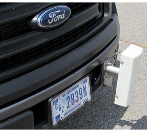
ITD collaborated to install sensors on three INL scout vehicles patrolling the bus routes ahead of daily scheduled bus trips. Collected data on pavement conditions is uploaded in real time to the Vaisala Navigator website for use by INL dispatch and management. Data is also used by ITD district operations to guide road-treatment choices and timing. These mobile data sets are a valuable supplement to data from the fixed Road Weather Information Systems (RWIS) sites.
Pictured below is a data recorder mounted on an INL scout vehicle.
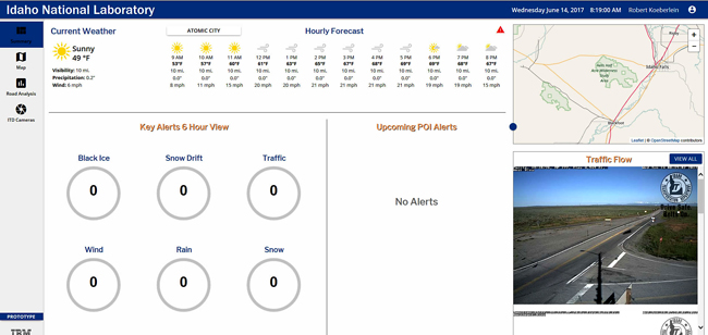
IBM “Watson” Artificial Intelligent Weather Forecasting Model
INL contracted with IBM to develop a high-resolution weather forecasting model using artificial intelligence. A “beta” version is being evaluated by INL and ITD. Millions of data values are examined to identify correlations between historical RWIS data and atmospheric observations data that together predict “slick” road conditions. A dashboard screen provides an interface to the most critical segments, calculated from the current forecast from the National Weather Service and other sources, coupled with the correlation relationships of the historical data model. The result is a library of customized forecasts for contiguous small segments of the INL bus route network.
Another dimension of the “Watson” artificial intelligence application is analyzing video images from RWIS cameras and interpreting road conditions. The model has the ability to learn based on initial input from the users, and the accuracy improves as more video images are analyzed. Analytics provide a means to automatically screen camera images in real time to identify hazardous driving conditions, providing a means to validate data from road sensors.
IBM has agreed to include ITD access in the final version of the model. After ITD gains experience with the model, expanded deployment may be considered. ITD will meet with INL in July to discuss next steps. After a winter season of experience with the model in eastern Idaho, the department will then evaluate contracting with IBM for a statewide application if funding allows.
Other Possibilities
ITD and INL are also looking into the possibility of delivering text-message alerts to the INL bus fleet (more than 75 buses during the work week), triggered by data from the fixed RWIS sites. Bus drivers use tablet computers for their daily operations, and these could be configured to accept text alerts. No texting and driving, of course!
Published 06-16-17