![]()
Treasure Valley commuters can use new 511 option
to monitor traffic congestion, interstate speed
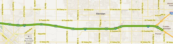
ITD is piloting a new option for commuters along I-84 between Caldwell and the Gowen Road interchange and between I-84 and downtown Boise using the Connector (I-184).
Blue Tooth signal receivers have been installed along the interstate that track vehicles and report travel times on the 511 Website. The 28-mile stretch is divided into eight segments, and another that leads to downtown Boise.
Drivers can check the website (511.idaho.gov) before they leave home or their work site to determine whether traffic is slowed by crashes or congestion. Information is available in near-real time on the 511 system’s high bandwidth site and is accurate within about five minutes on the low bandwidth site.
Computer users can place their cursor over a highway segment to receive an estimate of the traffic speed in either direction.
Traffic flow is displayed in color along the 511 system’s Treasure Valley map – green for free-flowing traffic, yellow for slower-moving traffic (20 to 40 mph) and red for heavily congested routes (20 mph or slower).
 The map shows two “bands” along the interstate to indicate eastbound and westbound traffic.
ITD’s 511 system also “paints” highway routes a specific color based on driving conditions, showing good, fair or poor travel, especially during winter months. The condition reports and congestion reports cannot be viewed simultaneously because both paint the roadways with color-coded information.
Users who want congestion reports will find the road condition option automatically de-selected. Selecting the condition report will de-select the congestion option.
Initial tests show the congestion reporting option is working well along I-84, although a detector in downtown Boise malfunctioned and sometimes gives an erroneous report for inbound traffic. That technical difficulty should be resolved soon, Ernest said.
A third option recently added to the 511 system improves access to highway reports for commercial vehicle operators. ITD added a new high bandwidth version of the trucker’s page this fall.
The Google-based maps load slower on the high bandwidth sites but provide additional functions not available on the low bandwidth site.
The trucker’s site includes height, weight, width and length restrictions that affect commercial traffic. It is especially important during “spring breakup” when thawing conditions make highway bases more vulnerable to heavy loads. Load limits will be posted on the Website when in effect.
Highway closures and delays also are posted on the truckers’ page, along with highway grades and mountain passes. Users can turn reporting options on and off easily.
ITD introduced the 511 system in 2007 to improve travel safety and help motorists make more informed travel decisions. It is part of the department’s mission to improve mobility for all highway users.
Published 2-24-2012