![]()
 Avalanche concerns remain
for section of Idaho 21
The return of warmer weather and first signs of spring - birds chirping, flowers blooming, fresh breezes blowing – usually are welcome after a long, cold winter.
Usually.
For ITD's avalanche forecasters on Idaho 21 it often means things are about to become much more fluid.
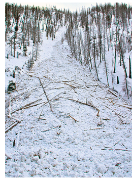
Warm spring weather melts snow, and the runoff combines with rains to create unstable snow packs in the notorious "Avalanche Alley" section between the Grandjean Junction turnoff and Banner Summit.
That segment, victimized by 50 slides that have reached the highway since Nov. 1, is home to about 60 known avalanche chutes and 90 percent of the avalanches in the state that affect highways.
Winter in the Avalanche Alley region unofficially runs from Dec. 1 through April 30. Spring snows are not uncommon, however, so the avalanche season can be just an estimate.
Although most people are tired of winter weather and long for the return of balmy days, rapid heating can create major concerns on the mountainside. Colder temperatures help stabilize the existing snowpack.
Bill Nicholson, ITD's head avalanche forecaster, noted that while the amount of snow on the ground is significant, the more important indicator of avalanche danger in warm-weather conditions is the temperature of the snow at different depths.
"As spring weather warms and snow melts, it becomes more slushy during the day and refreezes at night," he explained. "The temperatures help us get a picture of how deeply the warmth is penetrating and can foreshadow avalanches."
Nicholson and his avalanche crew will continue daily forecasting through the end of April.
Published 4-20-2012