![]()
ITD develops tablet 'app' to help pilots navigate Idaho skies, airstrips
 ITD recently developed and released an “app” for electronic tablets that will improve safety for pilots flying into and out of Idaho airstrips. The app is believed to be the first of its kind in the nation.
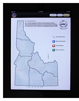
The Division of Aeronautics developed the Airport Facilities Directory for computer tablets. It provides information and runway diagrams for 134 Idaho airports and aviation facilities along with general flight information.
“Electronic flight bags are rapidly becoming the standard for pilots, replacing paper charts and publications, saving cost, weight and time,” said John V. (“JV”) DeThomas, Idaho Division of Aeronautics administrator.
GPS navigation, in-flight and destination weather, and now detailed information about Idaho’s public use airports are all on a single device at a pilot’s fingertips.
“It seemed like a natural evolution for our facilities directory,” said Mark Lessor, with ITD Aeronautics. “We searched for other states’ airport directory apps and none were available.”
The new app may be obtained as a free download for the iPad and soon will be available for Android-powered tablets.
“Many aviation apps, such as GPS and weather, are subscription-based and require a fee,” Lessor said. “ITD’s new app will save pilots the $10 we currently charge for the paper version.” He added that because ITD built the application in-house, cost was minimal for development and upkeep.
“Idaho’s iPad version of the Airport Facilities Directory is probably the first state version in the United States,” DeThomas said. “Needless to say, we’re really proud of this product.”
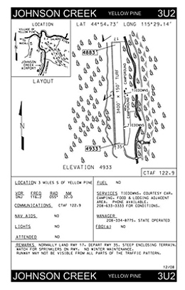 Pilots can access aviation facilities and diagrams for each of the Gem State’s airports, pristine backcountry airstrips and four seaplane bases by calling them up from an alphabetical list or by touching them on a graphical map.
Melissa Kaplan, ITD airport planner and a pilot, said that while she’s new to the idea of using the application on an iPad she said she will find it a convenient storage source to reduce the clutter in the cockpit.
“I still keep hard copies of charts and the Airport Facilities Directory within reach for backup but it is much easier to get to the pages needed when they are on my kneeboard,” she said.
The directory was compiled from many sources, including airport inspections, Federal Aviation Administration publications and airport owners and managers.
General flight information is at a pilot’s fingertips such as Emergency Locator Transmitter instructions, important Federal Aviation Administration telephone numbers, search and rescue procedures, and mountain flying tips.
ITD’s tablet application also provides a Crosswind Component Chart, a KOCH chart for calculating altitude and temperature effects on takeoff runway distances, important high altitude frequencies for those flying instrument flight rules (IFR) and an FAA flight plan form.
In-flight intercept procedures and tips for preventing runway incursions also are provided.
“We plan to update this app at least annually, but we will also have the capability to quickly get out critical safety information regarding airport changes if need be,” Lessor said.
Tony Garcia and Rik Hinton of ITD's Communications Office, along with Wendy Bates in Planning-GIS were heavily involved in development of the application. Tom Marks in Planning-GIS helped manage the airport data for the original base map.
“We gave the iPad app a pretty thorough check in several aircraft and in various light conditions, in landscape and portrait view, on a kneeboard and mounted in the aircraft, and in bumpy and smooth air,” Lessor said. “Test pilot stuff, if you will.”
“The touch-screen easily cleans with the white silk scarves all pilots wear,” he quipped.
Once tested and refined, ITD’s AFD application was submitted to the Apple App Store where it was checked for functionality, accepted and made available to the public for download.
Published 7-20-2012