![]()
District 5 merges as-built plans with satellite imagery to save hundreds
of development hours
A few months ago, District 5 GIS Analyst Nik Sterbentz discovered a way to merge as-built project plans with satellite imagery, saving hundreds of hours for development teams designing projects.
“He set about working out a way to help manage approaches; and accomplished it,” exclaimed District Engineer Ed Bala. “What makes it even cooler is that it can be used for so much more.” Bala is referring to the coordination of project accesses, culvert inventory, utilities and more. 
The catalyst for the innovation was a stretch of U.S. 89 (milepost 0-6) that had become problematic because of a proliferation of entrances and egresses — many of these accesses developed without the district ever issuing a permit, or even being contacted or informed until after the fact.
The stretch of highway starts at the Utah border. “There’s a lot of development there, because it’s along the shore of Bear Lake, a popular resort destination,” explained Sterbentz (pictured left).
Sterbentz said the project was about keeping track of the accesses, which could prevent a situation where there are more crashes. But he said the access project on U.S. 89 is just the tip of the iceberg. By georeferencing the plan scans, it saves a lot of time typically devoted to planning, design and other ITD workflows that require referencing as-constructed plans.
The plans representing the current alignment of ITD’s routes are a wealth of information for planners, designers and others, both within and outside the department. This GIS innovation makes accessing that information both highly intuitive and efficient.
In March, Sterbentz began working with D5’s permit coordinator to map approach accesses on the stretch of U.S. 89. He overlaid electronic pages of the as-constructed plans (retrieved from ITD’s electronic-document repository) on imagery to find pre-existing approaches. This was done using a process in ArcGIS called georeferencing, where known points on a map are used as “anchors” to place a map in its correct geographic location. ![]()
Thanks to the Multi-State Control Point Database (MCPD), a project to make highly-accurate GPS locations available for reference as GIS features, numerous high-grade locations were available to use as georeferencing anchors in District 5.
“The georeferenced planset pages and underlying imagery lined up great together,” said Sterbentz. “GPS data collected in the field, such as the locations of accesses for the project or culverts for our asset inventory, lined up as well."
“At that point my thought became that this could be done for the entire district,” he added. “Thanks to the support of the Headquarters GIS team and their tireless maintenance of GIS upgrades and infrastructure, the resulting overlay can be published to a GIS server and accessed by IPLAN users in a web browser.”
Sterbentz was able to accomplish this by matching coordinate information on the plans to the same information housed in the MCPD database (which is also embedded in the satellite imagery). The database is housed at Idaho State University; information is contributed to it by area consultants and ITD. Since ITD and these entities have been sharing data for a few years now, the database is a very rich environment.
Sterbentz is now working on georeferencing plansets for the remainder of D5 (which he estimates will take another five to six months) and exploring options to make the online display as effective as possible. This will be a service available through IPLAN, and accessible internally to assist in workflows across the department. However, content in IPLAN can be made available to the public, whether to the entire world or a subset of ArcGIS Online users in a group (such as local utility company contacts). This information, which is often confined to paper copies and the physical structures they are housed in, now has the potential to be viewed at will using a digital map. 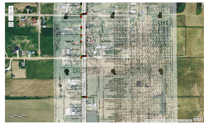
Anything that streamlines the processes of the district is of keen interest to leadership, and Bala has taken note of Sterbentz’s accomplishments.
“One of the first tasks employees perform as they design a project is to assess existing conditions,” Bala explained. “In the past, this involved referencing the as-built plans on a paper format, followed by a field trip. With Nik’s GIS product, they can do all that without leaving their desk. It’s remarkable how well everything lines up, and also that employees can now design simple projects like CRABS or overlays with no more information than what they can access through this GIS improvement.”
“It’s difficult to state the amount of time savings for the innovation, since Nik is in the process of referencing all the information in the district. I estimate the designer time savings at about 600 hours per year for D5. The 600 hours of field/file reconnaissance can now be devoted to other tasks.”
Pictured above is a satellite photo background, with as-built plans (from 1939) superimposed over the top. The colored dots you see are culvert ends, which were physically located in the field using handheld GPS devices as part of D5's physical asset inventory. (Sterbentz could invoke other layers like signs or guardrails that were tagged in a similar manner.)
Published 06-12-15