
| CONNECTIONS |
IDAHO
ITD
HOME
511 TRAVEL SERVICES
IDAHO
DMV
ITD
NEWS
HIGHWAY
SAFETY
IDAHO STATE POLICE
STATE OF IDAHO
NIATT
NATIONAL
AASHTO
AAMVA
AAA of IDAHO
FEDERAL HIGHWAYS
FEDERAL AVIATION
IDAHO STATE POLICE
NHTSA
NTSB
TRB
U.S. DOT
TRANSPORTER
Archives
Milestones
Comments
Idaho
Transportation
Department
Office of Communications
P.O. Box 7129
Boise, ID 83707
208.334.8005
Fax: 208.334.8563
![]()
State's two largest fires burning nearly 415,000 acres
Fire
activity report from the
National Interagency Fire Center,
as of Thursday, Aug. 23
 National
preparedness level: 5 (maximum)
National
preparedness level: 5 (maximum)
Active fires: 56
Acres: 1,804,962
New fires:
WFU (Wildland Fire Use) fire: 4
WFU acres: 78,437
Update:
Aug. 23, 2007
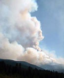
Photo: Rattlesnake fire south of Elk City.
Source: National
Interagency Coordination Center
The Idaho Transportation Department provides information about road closures on-line at 511.idaho.gov or dialing 5-1-1. Visit the Boise National Forest website for fire restriction information. Visit the Payette National Forest website for fire restriction information. |
Mitchell (Idaho Falls District, Bureau of Land Management): 9,730 acres at 95 percent contained. This fire is 10 miles north of Holbrook. Smoldering fire activity with isolated spotting was reported. Information: Call 702-622-5754 |
Castle Rock (Sawtooth National Forest): 15,575 acres at nine percent contained. This fire is eight miles west of Ketchum. Short uphill crown runs, torching and short-range spotting was reported. The community of Ketchum is threatened. Evacuations are in effect. Information: Call (208) 726-7811. |
Bridge (Clearwater National Forest): 36,150 acres at zero percent contained. This fire is 45 miles southwest of Missoula. Creeping and smoldering was reported. Information: Call (208) 942-3113 or visit the Grangeville Interagency Dispatch web site. |
Poe Cabin (Craig Mountain Area Office, Idaho Department of Lands): 58,520 acres at 95 percent contained. This fire is 23 miles southwest of Grangeville. Smoldering was reported. Information: Call (406) 203-4954 or visit the Grangeville Interagency Dispatch website. |
Cascade Complex (Boise National Forest): 211,353 acres at zero percent contained. The previously reported Landmark Complex has been added to this complex. This complex is 16 miles northeast of Cascade. Creeping and smoldering was reported. The Warm Lake and Paradise Valley communities remain threatened. Road closures and evacuations are in effect. Information: Call (208) 632-2810. For information on road closures, contact the Valley County Sheriff at 208-382-7150 |
Landmark Complex (Boise National Forest): Information:
Call 208-633-2807. For information about road closures visit the
Central Idaho
Fires web site. |
East Zone Complex (Payette National Forest): 203,569 acres at 10 percent contained. This complex is made up of three fires. This fire is 25 miles northeast of McCall. The Secesh, Warren, and South Fork communities remain threatened and evacuations are in order. Creeping and smoldering fire behavior was reported. Information:
Call (208) 634-1890 or visit the Payette
National Forest website. |
Rattlesnake (Nez Perce National Forest): 90,763 acres at zero percent contained. This fire is 25 miles south of Elk City. Community of Concord, ranches, and recreation sites are threatened. Backing fire with occasional torching was reported. Information:
Call (208) 842-9225 or visit the Grangeville
Interagency Dispatch website. |
Shower Bath (Salmon-Challis National Forest): 58,000 acres at zero percent contained. The fire is located 18 miles northwest of Challis. Structures, historic cabins, and cultural sites remain threatened. Creeping and smoldering were reported. Information: Call 208-861-1568. |
Cleveland (Idaho Falls District, Bureau of Land Management): 16,269 acres at an 96 percent contained. The fire is 12 miles northeast of Preston. No new information was received. This will be the last report unless new information is received. Information:
Call 702-622-5754. |
Boundary Junction (Clearwater National Forest): 5,088 acres at an zero percent contained. This fire is 15 miles southeast of Pierce. Smoldering was reported. Information:
Call 208-926-4274. |
Red Bluff (Salmon-Challis National Forest): 43,870 acres at zero percent contained. The fire is burning 31 miles northwest of Challis. Structures are threatened. Recreational activity on the Middle Fork of the Salmon River has been suspended. Creeping and smoldering was reported. This fire will be incorporated into the Shower Bath Complex. Information: Call (208) 756-5145 or visit the Salmon-Challis National Forest website. |
Clear
Sage (Salmon Cahllis National Forest): 8,200 acres at
an unknown percent contained. The fire is located 25 miles northwest
of Salmon. Creeping, and smoldering were reported. This fire will
be incorporated into the Shower Bath Complex. |
WFU:
Krassel Complex (Payette National Forest): 59,135 acres.
This Wildland Fire Use (WFU) complex is being managed to accomplish
natural resource objectives. It is located 44 miles northeast
of Yellow Pine. Active surface fire was reported. Information:
Call (208) 634-0983 or visit |
Published 8-23-07