
| CONNECTIONS |
IDAHO
ITD
HOME
511 TRAVEL SERVICES
IDAHO
DMV
ITD
NEWS
HIGHWAY
SAFETY
IDAHO STATE POLICE
STATE OF IDAHO
NIATT
NATIONAL
AASHTO
AAMVA
AAA of IDAHO
FEDERAL HIGHWAYS
FEDERAL AVIATION
IDAHO STATE POLICE
NHTSA
NTSB
TRB
U.S. DOT
TRANSPORTER
Archives
Milestones
Comments
Idaho
Transportation
Department
Office of Communications
P.O. Box 7129
Boise, ID 83707
208.334.8005
Fax: 208.334.8563
![]()
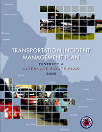
ITD revises incident management plan,
includes new statewide detour maps
 ITD’s emergency program office introduced an updated Transportation Incident Management Plan late this summer that contains an important new feature – clear identification of preferred detours designed to keep traffic flowing during highway closures.
Mapping detours for most of Idaho’s state highways has been a two-year process, guided by consultant Kimley-Horn, an Arizona-based company that recently opened an office in Meridian, explains ITD’s Bryan Smith. Distribution of the new incident management plan began in late August, providing first-responders with a new tool in managing highway events.
The plan is available to law enforcement officers, highway districts, fire departments and Emergency Management Service providers and is included as an annex to the Idaho Emergency Response Plan, Smith adds.
ITD also is distributing a “Quick Reference Guide” along with the Incident Management Plan to serve as a field manual to responders. Both guides, including the detour plan, are available on the ITD Web site, itd.idaho.gov under “Publications.” It can be viewed online or downloaded and printed.
“Basically, it explains how ITD wants to manage incidents on state highways,” Smith explains.
Pre-planned detours give law enforcement officers and first responders an option for managing traffic and enables them to focus more on the incident itself, Smith says. The routes are not mandatory, but serve as the best alternatives in the event of a state highway closure.
Car crashes, hazardous materials spills and other events can result in lengthy delays, which create an inconvenience to motorists and a financial impact on commercial traffic.
“It demonstrates our commitment to safety, service and delivery of a quality product,” Smith says of the detour plan.
Most of Idaho’s six transportation districts previously developed detour plans, but the new statewide version standardizes those plans and adds consistency. “Now all of our districts are on the same level.”
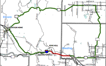 ITD and Kimley-Horn met with constituents throughout the state – including county and city officials, EMS providers and law enforcement to identify detours that are capable of accommodating traffic that would be routed off the state highway system. Their recommendations considered traffic volume and speed, and factors that might limit commercial vehicles.
The plan also identifies the most appropriate place for traffic control – including flaggers and variable message signs.
ITD’s Transportation Incident Management Plan, which has been distributed to and accepted by the Idaho State Police and other agencies, identifies highway incidents by the anticipated length of traffic interruption. Response level A relates to an incident that is expected to take up to 30 minutes to clear. Response level B is for incidents expected to take between 30 minutes and two hours, while level C is for incidents that are expected to take more than two hours to detect and clear.
Official notifications of a road closure are made to the news media for events that are expected to last more than two hours. All incidents, however, will be entered into the 511 Traveler Services Web site (511.idaho.gov) or the interactive 511 telephone system. By Idaho code, ITD has the sole authority to close an interstate or state highway.
Smith is not aware of a highway incident that has required implementation of the new detour plan yet. The plan still is being introduced and does not outline a formal reporting strategy. Responders may use the detour plan without notifying ITD’s emergency program office.
The last major revision to ITD’s Transportation Incident Management Plan was made before the Sept. 11, 2001, terrorist attacks.
With changes in technology, Smith hopes the next revision will incorporate Google map technology that enhances route identification and could be integrated into a future generation of Idaho’s 511 system. The Ada County Highway District already uses a similar technology for traffic incidents in the Treasure Valley.
Published 9-12-8